INTERNATIONAL MARITIME BOUNDARY LINE AND KACCHATHEEVU ISSUE | Current Affairs | Vision IAS
Monthly Magazine Logo

Table of Content

INTERNATIONAL MARITIME BOUNDARY LINE AND KACCHATHEEVU ISSUE

Posted 15 Apr 2024

3 min read

Why in the news?

Sri Lankan fishermen protested against their Indian counterparts for their alleged poaching in the Sri Lankan waters by sailing to the International Maritime Boundary Line (IMBL).

More on the news

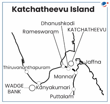
  • The problem has three interrelated facets: disagreements over Kachchatheevu island; poaching by Indian fishermen in Sri Lankan waters; and their use of trawlers that causes environmental damage.
  • While Indian fishermen believe they are simply fishing in their traditional grounds, particularly around Katchatheevu, Sri Lanka accuses them of trespassing into its territorial seas
  • Indian fishermen claim that climate change and depletion of fish stocks on the Indian side of the IMBL have driven them to sail farther out to sea.
  • In 2023, 240 Indian fishermen were arrested for alleged poaching in Sri Lankan waters, followed by the seizure of 35 trawlers.

About International Maritime Boundary Line (IMBL) 

  • The India-Sri Lanka IMBL was delineated by the 1974 Maritime boundary agreement demarcating it in the Palk Strait. 
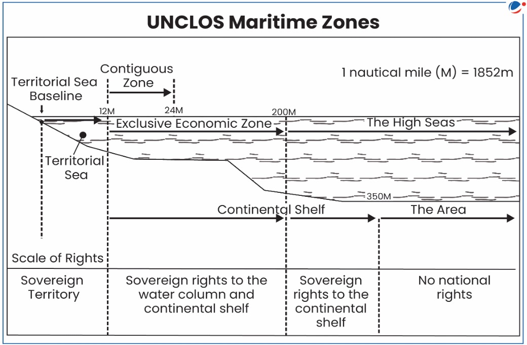
  • It was determined based on principles under United Nations Convention on the Law of the Sea (UNCLOS). 
  • According to UNCLOS, Maritime boundaries are often defined by the equidistance principle, which asserts that a nation's marine boundary should follow a medial line equidistant from the coastal areas of two neighbouring countries.
  • This boundary is established to define each country's exclusive economic zones, territorial waters, and other maritime zones, helping to prevent disputes and conflicts over maritime jurisdiction.

The Katchatheevu Island Issue

  • About Katchatheevu and Wadge Bank
    • Katchatheevu is a 285-acre patch in the sea within the maritime boundary line of Sri Lanka.
    • It is located to the northeast of Rameswaram and southwest of Sri Lanka’s Delft Island. 
    • It was created by a 14th-century volcanic eruption, is 1.6 km in length and just 300 metres wide at its widest point.
    • Wadge Bank is one of the world’s richest fishing grounds and in a much more strategic part of the sea than Katchatheevu Island.
  • Article 15 of UNCLOS allowed exemptions from using the median line to determine maritime boundaries, acknowledging adjustments agreed upon by the contracting nations.
  • 1974 Agreement between India and Sri Lanka established an adjusted equidistant line under this exemption. As a result, Katchatheevu Island fell within Sri Lanka's maritime boundaries.
    • Indian fishermen were given access to Katchatheevu for rest, for drying of nets and for the annual St. Anthony Church festival.
  • Later, the 1976 agreement between the countries settled the maritime boundary between by giving sovereign rights to India over Wadge Bank near Kanyakumari.
    • Sri Lankan fishing vessels were prohibited from fishing in the Wadge Bank, except for a limited number under specific conditions.
  • Tags :
  • IMBL
Download Current Article